
An impossibly slender pillar of earth balances a slab of rock on its head. It has stood this way for a long time, but it will not stand forever.
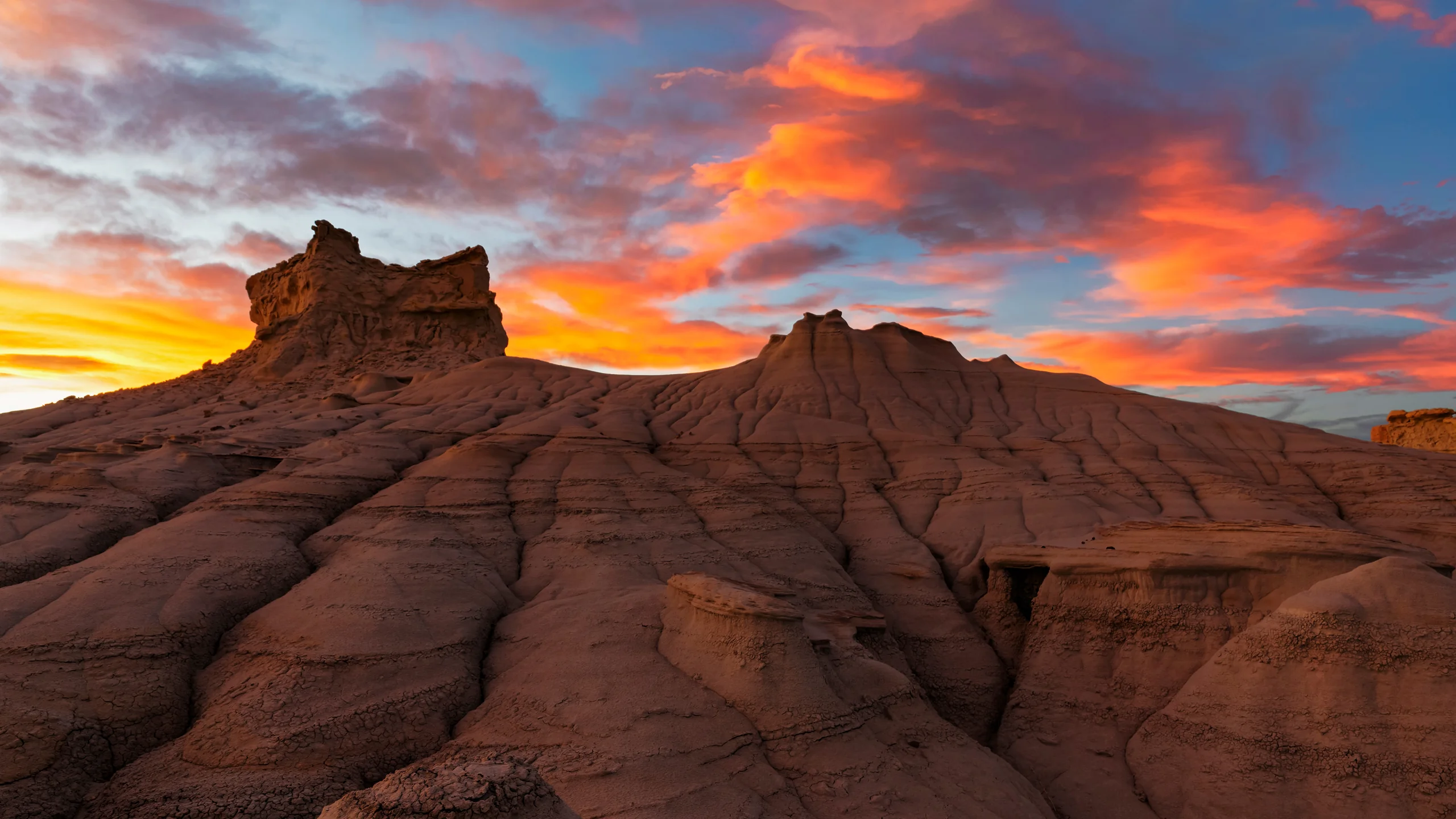
Image: Bing Daily Wallpaper · Hoodoo in the Ah-Shi-Sle-Pah Wilderness, San Juan County, New Mexico, USA (© Westend61/Getty Images) · Bing title: "A Masterful Balancing Act"
Open Bing today and a stone pillar stands on the homepage.
It is thin enough to make you uneasy. The shaft is gray-white, layered in earthy bands and seemingly as soft as a cake left out too long. On top sits a dark slab two or three times wider than the column beneath it. Instinct says it could topple at any moment. It will, in fact - just not today.
This is Ah-Shi-Sle-Pah, in the northwestern corner of New Mexico's San Juan County: a desert wilderness with no roads, water or toilets and almost no mobile signal. On March 12, 2019, the US Congress passed the John D. Dingell, Jr. Conservation, Management, and Recreation Act, formally designating about 7,242 acres, or roughly 29 square kilometers, as federal wilderness - the country's highest tier of land protection. It is managed by the Bureau of Land Management's Farmington Field Office. Ah-Shi-Sle-Pah is commonly said to mean "gray salt" in Navajo, an interpretation also used by the scholars who named a new local dinosaur in 2025. The BLM's own page offers no etymology, however, so "gray salt" remains the conventional explanation, not an official one.
That Hat Is Not Decoration. It Is an Umbrella
First, how did this pillar grow? Strictly speaking, it did not. The land around it became lower.
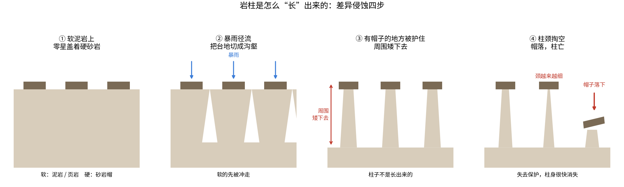
Three words in the BLM's official description are crucial: "carved by water." The pillar consists of soft mudstone and shale that crumble under a downpour. The cap is better-cemented sandstone, probably a body of sand left by an ancient river channel more than 70 million years ago. Stack rocks of such different hardness together and geology's simplest principle takes over: differential erosion.
Every storm then repeats the same operation. Where there is no cap, rain strips away the mud layer by layer and lowers the ground year after year. Beneath a cap, raindrops first strike sandstone, sheltering the mud below. Once the surroundings have been cut down by several meters, the protected earth remains as a column. The pillars never rose. Everything else left.
The New Mexico Bureau of Geology and Mineral Resources gives the same explanation for hoodoos elsewhere in the basin: a harder layer of brown sandstone forms the cap, shielding the softer pale sandstone beneath it.
Here is the turn, and the most affecting thing in the photograph: the hat is both umbrella and executioner. It blocks the rain, but water works around its edges and continues excavating the pillar's neck. The neck grows thinner until, one day, it can no longer bear the cap's weight. The slab falls, and the now-unprotected pillar rapidly disappears in the storms that follow.
Every hoodoo is therefore counting down. The one on Bing's homepage is a sculpture destined to collapse. The more perfectly it stands today, the closer it is to the final rain.
Not Wind but Rain - and What "Yardang" Actually Means
To a Chinese viewer, this photograph may immediately suggest a "ghost city" or a yardang. The association is natural, but the landforms are not the same. The crucial difference is the tool that carved them.
A yardang is the work of wind. Sand-laden air abrades and scours the ground year after year, cutting it into ridges aligned parallel to the prevailing wind. The upwind end is blunt and steep; the downwind end tapers and descends. Yardangs resemble a fleet, every vessel pointing the same way. The word itself comes from Uyghur and means a small hill with a steep face.
A hoodoo is the work of water. Runoff from sudden storms follows fractures downward, cutting a plateau into a maze of gullies and badlands. Pillars stand here and there along the drainage network, with no common orientation.
The arrangement provides a reliable distinction. Parallel forms pointing the same way have been combed by wind; isolated, cap-topped pillars have been chiseled by rain.
The two terms are often blurred in Chinese. The government website for Zanda County in Tibet calls its famous earth forest a "yardang landform," while a popular-science article from the Chinese Academy of Sciences' Institute of Geology and Geophysics carefully distinguishes earth forests from yardangs: running water carves the former, wind the latter. This is not pedantry. Confusing the names skips the real question of how the formations came to be.
A Claim That Needs Correcting: 75 Million Years Is Not the Time Spent Carving
Bing's own English copy says wind, water and ice spent "around 75 million years" sculpting these badlands.
That sentence collapses two different histories into one. Seventy-five million years is the age of the rock, not the duration of the carving.
The exposed strata here belong to the upper Fruitland Formation and the lowest Kirtland Formation, dating to roughly 75 million to 74 million years ago in the Late Cretaceous. This was not a desert then, but a tropical coast beside the Western Interior Seaway, a landscape of swamps, rivers and deltas where peat accumulated and channels wandered. The black coal seams visible in the wilderness are receipts from those swamps. The sandstone cap atop the pillar is the remnant of an ancient river channel.
The tool that cut those rocks into gullies and pared them into columns began its work much later, after the strata rose and rivers started cutting down through them. For a sense of scale, Badlands National Park in South Dakota gives an official erosion rate of about one inch, or 2.5 centimeters, per year and estimates that its badlands will be gone in roughly 500,000 years. That figure is from South Dakota, not New Mexico. No measured local erosion rate for Ah-Shi-Sle-Pah was found. It nevertheless shows that badlands are sculpted on a scale of hundreds of thousands of years, not tens of millions.
The rock is ancient. The sculpture is young. The two must remain separate.
How, Exactly, Is a Hoodoo Cut Apart?
One explanation for hoodoos has spread widely: water seeps into cracks, freezes overnight and expands by about 9%, acting like a pry bar that gradually forces the rock apart. Bryce Canyon National Park in Utah experiences more than 170 nights a year when temperatures cross the freezing point, so freeze-thaw wedging sounds entirely plausible there.
Then the National Park Service published an article whose title amounted to "We Don't Know How Bryce Canyon's Hoodoos Form." It acknowledged that every citation for the freeze-thaw hypothesis ultimately traces back to a 1980 thesis, and no peer-reviewed paper has yet validated it. A park physicist put the point plainly: formally speaking, we do not know how hoodoos erode. The same article noted that Bryce now experiences about 50 fewer freeze-thaw days than it did 60 years ago, while average low temperatures have risen by about 7 degrees Fahrenheit.
The limits of that admission matter. Differential erosion and the role of caprock are not in dispute; they are visible in this photograph. What remains contested is how much work is done by each chisel: freeze-thaw action, dissolution and salt crystallization. Bryce is also a high limestone plateau at roughly 3,000 meters, while Ah-Shi-Sle-Pah is lower country made of mudstone and sandstone. The tools need not operate in the same proportions.
The lesson is not simply that scientists do not know. It is that what science has established can and must be distinguished from what remains in dispute.
Dinosaurs Are Buried in These Pillars, and They Are Still Emerging
The wilderness is better known for fossils than for scenery.
In 1921, the celebrated fossil hunter Charles Sternberg excavated a horned dinosaur with its skull in this area and sold it to Uppsala University in Sweden. In 1930, Uppsala paleontology professor Carl Wiman used the specimen to name a species of Pentaceratops. Ceratopsians such as Pentaceratops had extraordinary skulls. A giant specimen described in 1998 had a skull nearly three meters long, which the paper called the largest known skull of any terrestrial vertebrate.
The startling part is the wait.
In 2025, researchers named a new hadrosauroid genus after this wilderness. Its holotype had been collected here by a geologist in 1916. It spent 109 years in a museum cabinet before receiving a name. The species name honored Wiman, who had studied Sternberg's fossils in Sweden.
More recently still, on August 3, 2026 - 12 days before this image appeared as Bing's wallpaper - two researchers published a new troodontid species. Its fossil, a left frontal bone collected from a neighboring stratum in the summer of 2005, had waited 21 years; the genus name comes from the Navajo people's name for themselves. In March of the same year, another team described a huge tibia from the same sequence in Scientific Reports. They assigned it to the largest tyrannosaurid known from the Campanian, with an estimated mass of 4.5 to 5 metric tons.
The fossils of this wilderness have not finished coming out of the ground. The excavation has simply moved into museum drawers. A bone picked up in 1916 waited 109 years. A frontal bone boxed in 2005 waited 21.
Fossil-Collecting Rules
On US federal land, vertebrate fossils may not be excavated, collected or removed, nor may molds or casts be made, without a scientific permit. Anyone who finds a potentially important fossil should leave it where it is, photograph it, record the location and report it to the local office.
Limited personal collection of invertebrate and plant fossils is allowed on some federal land, but rules are stricter in designated wilderness. The neighboring Bisti/De-Na-Zin Wilderness expressly prohibits collecting petrified wood. Local media say that taking petrified wood or anything else from Ah-Shi-Sle-Pah is strictly forbidden, while the BLM's own page says only that collection is restricted under applicable rules. Because those formulations do not fully agree, the only prudent conclusion is to take nothing. Motor vehicles, bicycles and drones are also prohibited, as is climbing on or damaging the hoodoos. The fragile neck beneath each cap explains why.
China's Kindred Earth Forests
The finest thing about this photograph is that the same mechanism is visible in China, in more than one place.
The Chinese Academy of Sciences' Institute of Geology and Geophysics defines an "earth forest" as a group of columnar landforms made from earthlike deposits that have not fully consolidated into rock and have been shaped by running-water erosion. A hard ferruginous weathering crust or a calcareous or siliceous cemented layer must protect the top of each column, and the formations survive only in arid or semi-arid regions. Qian Fang first applied the name "earth forest" to this landform in 1977.
The correspondence with Ah-Shi-Sle-Pah is exact: soft body, hard cap, differential erosion, running water, arid country, a short life and collapse when the cap falls. It is the same problem worked out in another landscape.
China has three comparable earth forests:
- Yuanmou Earth Forest in Yunnan most closely resembles the scene in the photograph. It has three areas: Wumao, also called Hutiaotan; Banguo; and Langbapu. Langbapu lies in Xinhua Township, 33 kilometers west of Yuanmou County town, at an elevation of 1,560 to 1,640 meters. It developed in fine sand and clay deposited by a lake.
- Datong Earth Forest in Shanxi, about 22 kilometers southeast of the city at Duzhuang Village, is among China's youngest. Its ancient lake existed about 3 million years ago, while the present landscape formed only 20,000 to 30,000 years ago. It is also the most vulnerable of the three. A soil layer just 20 to 30 centimeters thick protects it, while salt crystals growing within the earth are especially destructive. Researchers say landforms taller than 10 meters have difficulty developing there.
- Zanda Earth Forest in Ngari, Tibet is the largest. Its Pliocene river and lake deposits reach a maximum thickness of 200 to 300 meters, and the area is a national geopark. This is the site mentioned earlier whose own government website calls it a yardang.
There is no anniversary behind this particular day's wallpaper. The wilderness received its federal designation on March 12, and the Wilderness Act dates to September 3. Bing simply rotated the photograph onto its Chinese homepage today. The pillar does not care about dates. It cares only about the next rain.
Sources: US Bureau of Land Management pages for the Ah-Shi-Sle-Pah Wilderness and National Conservation Lands; Wilderness.net; New Mexico Bureau of Geology and Mineral Resources; US National Park Service pages on Bryce Canyon hoodoos, the dedicated "We Don't Know" article and Badlands National Park geology; Sullivan's 2006 review of the wilderness's paleontology and history; March 2026 Scientific Reports paper; Sci.News reports on the new genera named in 2025 and 2026; Paleontological Resources Preservation Act and BLM fossil-collecting rules; Chinese Academy of Sciences Institute of Geology and Geophysics, "The Secrets of Earth Forests"; The Paper feature on Datong Earth Forest; National Geographic China scenic-area entry for Langbapu Earth Forest; Zanda County government website.