
NASA's Image of the Day for September 24, 2026: a quadcopter over the California desert carries a navigation system being developed for the Moon.
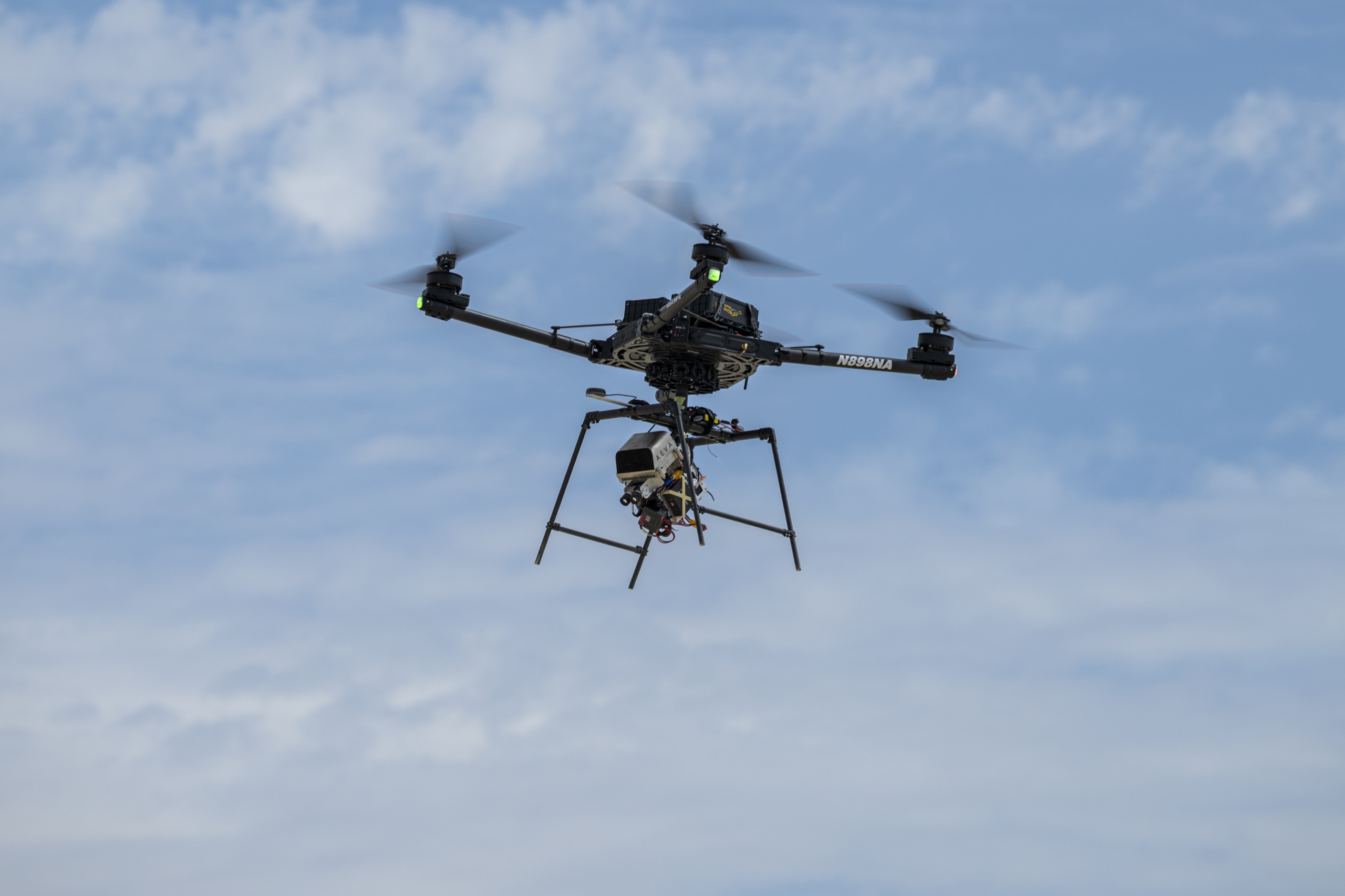
Image: NASA Image of the Day | Image credit: NASA/Ryan Kline | Original page
On Thursday, August 27, 2026, near Edwards, California, a quadcopter rose from the ground and flew over a stretch of barren terrain.
It could have been a hobbyist's weekend flight. The equipment underneath it, though, was intended to help spacecraft land on the Moon.
NASA chose the photograph as its Image of the Day for September 24. The official caption confirms one thing: an advanced guidance and navigation system called SPLICE recently completed simulated lunar descent and landing maneuvers in testing. The public account does not identify the components tested, give accuracy figures or describe any anomalies. Those details remain unconfirmed.
The system's background, and the problem it is designed to solve, are better documented.
No Road Signs on the Moon
On Earth, navigation depends on dozens of satellites overhead.
BeiDou and GPS work on the same principle. Satellites continuously broadcast their identity and the time. A receiver gathers signals from four or more satellites, compares their arrival times, and calculates its position. The system has become so cheap, reliable and ubiquitous that it is easy to forget it had to be invented.
The Moon has no equivalent network.
But that does not mean GPS signals cannot reach it. On March 3, 2025, LuGRE, a receiver developed by NASA and the Italian Space Agency aboard Firefly's Blue Ghost lander, successfully acquired and tracked signals from both GPS and Galileo on the lunar surface. It produced the first satellite-navigation position fix on the Moon, roughly 225,000 miles from Earth.
The signals reach that far. The question is whether they are sufficient.
Navigation satellites point their antennas toward Earth. Their main beams have limited coverage; NASA describes the strongest signals as lying within roughly 26 degrees of the main direction. More distant spacecraft must rely on weaker sidelobes. At lunar distances, too few satellites are visible at once, their geometry is poor, and the signals are weak. They can just about support orbit determination over extended periods. They are nowhere near enough for a powered descent from 10 kilometers up to touchdown, lasting little more than ten minutes, in which every second matters.
Earth's navigation network has barely reached the Moon. It is not yet enough to land by.
Finding the Way by Sight
The alternative sounds deceptively simple: let the lander see where it is going.
The technique is called Terrain Relative Navigation, or TRN. A camera takes photographs during descent and matches them against maps made by orbiters and loaded in advance. Shared terrain features reveal the spacecraft's position relative to the map.
It is much like working out where a street photograph was taken, except the spacecraft must do it alone, in tens of seconds, somewhere no one has visited and nothing has a street address.
The numbers show how demanding that is. The camera can take up to 10 images per second. In the Mars version described by the Jet Propulsion Laboratory, coarse matching uses three images and 15 landmarks, correlating 128-by-128-pixel templates within 1,024-by-1,024-pixel search windows. Fine matching uses up to 150 landmarks per image, comparing 15-by-15-pixel templates within 100-by-100-pixel windows. The reference maps come from an orbiter's high-resolution camera, at 12 meters per pixel for coarse positioning and 6 meters per pixel for fine positioning.
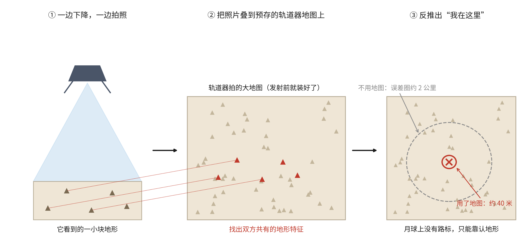
On Mars, relying on Deep Space Network positioning without TRN can leave a landing error of about 2 kilometers. With TRN, that falls to less than 40 meters. NASA gives another measure of the difference: the system raised Perseverance's probability of a successful landing in Jezero crater from just over 80 percent to 99 percent.
The actual landing exceeded the specification. On February 18, 2021, Perseverance touched down within 5 meters of the point targeted by its vision system.
In 1976, Viking's landing ellipse measured 280 by 100 kilometers. That was a landing region rather than a landing point. Today's engineers aim for something closer to half a soccer field.
Three More Pieces of Equipment
SPLICE stands for Safe and Precise Landing - Integrated Capabilities Evolution. Led by NASA's Johnson Space Center, the project began in October 2017. Other centers contribute: its Doppler lidar comes from Langley Research Center, and field testing of its three-dimensional imaging lidar takes place at Goddard.
Alongside the camera are three more components.
Navigation Doppler Lidar (NDL) takes over at about 10 kilometers altitude. Several laser beams, set at fixed angles, send out pulses whose returns measure three-dimensional velocity, height above the ground and descent rate. It makes 20 measurements per second, with much greater precision than conventional radar. NASA's official descriptions differ on the beam count: one gives three and another four. Both describe a system using several beams.
Hazard Detection Lidar (HDL) starts work at about 500 meters. It scans the surface below, builds a three-dimensional map in real time, and identifies landing sites free of large rocks and steep slopes. During Goddard field testing, the project manager described 16 million data points collected in two seconds, each accurate to about 1 centimeter.
The Descent and Landing Computer (DLC) is a dedicated, high-performance multicore processor, separate from the main flight computer. During those crucial minutes, it ingests and processes data from all three sensor systems.
Why So Many Landings Go Wrong
The Moon has a feature especially unkind to landers: almost no atmosphere.
NASA's Glenn Research Center states the trade-off plainly. A rocket leaving the Moon encounters no aerodynamic drag, but an arriving spacecraft cannot use that drag to slow down. It must rely on rocket thrust throughout its landing. There are no parachutes or cushioning airbags, and no atmosphere to shed 90 percent of the speed. The engines must do the work.
Apollo 11 demonstrated the difficulty in 1969.
On final approach, Neil Armstrong saw a large crater at the planned landing site, surrounded by boulders, the largest two or three meters across. At mission elapsed time 102 hours, 43 minutes, 15 seconds, he took manual control, reduced the craft's pitch from about 18 degrees to about 5 degrees, and maintained forward speed to clear the rocks.
The familiar account says he landed with only 25 seconds of fuel remaining. NASA's Apollo Lunar Surface Journal gives a more precise explanation. Postflight analysis found about 770 pounds of propellant left at touchdown, of which roughly 100 pounds was unusable. That left enough for about 45 seconds of engine operation. But 20 seconds had to be reserved for an abort that would return the ascent stage to orbit.
The famous 25 seconds therefore meant 25 seconds until the crew had to commit to landing or aborting, rather than 25 seconds until the tanks ran dry. Propellant sloshing in the tanks had also triggered the low-level warning nearly 30 seconds early, making the margin seem even tighter to the two astronauts.
They landed 6.6 kilometers from the intended point. Only 0.6 kilometer of that displacement came from avoiding the boulders; the other 6 kilometers came from the guidance system's error. That was the state of the technology 57 years ago.
Then there were the famous 1201 and 1202 alarms. During descent, rendezvous-radar pointing data kept flooding the computer in the background, overloading it. Mission Control allowed the landing to continue because the computer could recognize lower-priority work and discard it in favor of more important calculations.
The modern DLC offers a telling comparison. In 1969, the computer survived by dropping tasks. In 2026, the answer is to provide enough computing power. Sometimes 57 years of engineering progress means no longer having to choose what to abandon.
Recent missions show that landing itself remains difficult.
On January 20, 2024, Japan's SLIM lander achieved 3 to 4 meters of landing accuracy, a record for the Moon. But at an altitude of 50 meters, one of its two main engines lost thrust. It touched down in an unintended attitude, with its engines pointing upward, and could not generate electricity normally. Its navigation excelled; its landing did not.
A month later, on February 22, 2024, Intuitive Machines' Odysseus made the first U.S. soft landing on the Moon in more than half a century. Hours before touchdown, however, the team discovered that its laser rangefinders were not working. According to the mission press conference, a ground safety inhibit switch had been left engaged before launch and could not be released remotely. The team hastily switched to NASA's NDL, carried aboard as a technology demonstration. NASA later reported that NDL supplied 100 percent valid measurements from 10 kilometers altitude through touchdown. The lander ultimately tipped onto its side, but it reached the surface.
The results in 2025 were mixed. Firefly's Blue Ghost Mission 1 succeeded on March 2, landing, in NASA's words, "upright and stable." Just four days later, on March 6, Intuitive Machines' Athena touched down about 400 meters from its target, tipped over, and soon exhausted its batteries, ending the mission early. On June 6, the Japanese company ispace lost RESILIENCE in a hard landing. Its technical investigation identified a hardware anomaly in the laser rangefinder: degraded performance delayed the acquisition of valid ranging data, and the lander failed to slow to a safe speed.
The experiences of Odysseus and RESILIENCE make a stark pair.
In February 2024, a spacecraft with a nonfunctioning laser rangefinder was saved by a NASA instrument pressed into service as a backup. Fifteen months later, another spacecraft with a nonfunctioning laser rangefinder crashed.
That is why NASA keeps flying drones over the California desert.
Harder terrain lies ahead. Artemis is targeting the lunar south pole, where the Sun stays only a few degrees above the horizon and shadows stretch 25 to 50 times the height of the objects casting them. Permanently shadowed regions have not seen sunlight for billions of years, and crater floors reach temperatures below -200 degrees Celsius. With no atmosphere to scatter light, the sky is black and the contrast between light and shadow extreme. For navigation that depends on recognizing terrain in images, it is close to the hardest possible test.
The Lake Bed Has Its Own History
The drone's departure point is part of the story, too.
Armstrong Flight Research Center stands on the northwestern edge of Rogers Dry Lake. The dried lake bed is so level it looks poured, a natural runway. This was where Chuck Yeager first broke the sound barrier on October 14, 1947.
The center was formerly called Dryden. It became Armstrong on March 1, 2014.
Neil Armstrong worked here as a research test pilot from 1955 to 1962, flying 48 types of aircraft for more than 2,400 hours, including seven X-15 flights. He also worked on the Lunar Landing Research Vehicle, the strange machine resembling a flying bed frame that helped astronauts practice landing on the Moon.
He learned to land on the Moon above this lake bed, then did it seven years later. Fifty-seven years after that landing, NASA is back over the same lake bed, teaching machines the same skill.
Extending the Navigation Network
There are two answers to the problem of navigating beyond Earth's satellite network. One is to let landers find their way by sight, the capability SPLICE is developing. The other is to extend the network itself.
China's BeiDou-3 global navigation satellite system was completed and commissioned on July 31, 2020. Its 30 satellites comprise 24 in medium Earth orbit, three in geostationary orbit and three in inclined geosynchronous orbit. A white paper from China's State Council Information Office gives its global service performance as better than 9 meters horizontally, better than 10 meters vertically, velocity accuracy better than 0.2 meter per second, and timing accuracy better than 20 nanoseconds.
The same white paper sets out a next step: "Explore and test BeiDou service applications in Earth-Moon space, and promote the extension of BeiDou services into deep space."
A U.S.-Italian receiver has obtained the first navigation signals from Earth-orbiting satellites on the lunar surface. China's white paper sets a course for extending services into deep space. Both point toward the same ambition: carrying the navigation network around Earth farther outward.
Until that network is ready, a lander still has to see its own way down.
Sources
- NASA Image of the Day for September 24, 2026: Original page.
- NASA's SPLICE project page.
- NASA Johnson Space Center, "Technology Enables Precision Landing Without a Pilot."
- NASA Goddard's report on HDL field testing.
- NASA Space Technology Mission Directorate's Terrain Relative Navigation impact report.
- Jet Propulsion Laboratory Robotics, Mars 2020 Terrain Relative Navigation page.
- NASA's Apollo Lunar Surface Journal, annotations on the Apollo 11 landing.
- NASA Glenn Research Center, "Beginners Guide to Aeronautics: Moon."
- NASA's account of phenomena at the lunar south pole.
- NASA news releases on LuGRE's acquisition of GNSS signals on the Moon, the Odysseus landing, the Blue Ghost Mission 1 landing, and the end of the Athena mission.
- JAXA's announcement of SLIM landing results.
- ispace's technical findings on the RESILIENCE mission.
- NASA Armstrong Flight Research Center's history page and renaming news release.
- Freefly Systems' official Alta X specifications.
- State Council Information Office of China, the white paper "China's BeiDou in the New Era."
- Jet Propulsion Laboratory Education, "Touchdown."