
The fifth Doodle of US National Parks Week: Yosemite.

Image: Google Doodle, Celebrating National Parks Week: Yosemite · Official page on doodles.google
Google has put California on its homepage today. The official introduction is only two sentences long. It says the Doodle celebrates Yosemite, famous for its spectacular waterfalls, and shows the park's most recognizable mountain: Half Dome.
This is the fifth entry in the National Parks Week series. August 22 brought Grand Canyon and Acadia, August 25 Yellowstone and Great Smoky Mountains, August 26 another Great Smoky Mountains Doodle, and today Yosemite. US National Park Week in 2026 runs from August 22 to 30, moved to August from its traditional April dates. The National Park Service announcement notes that the timing coincides with the agency's 110th anniversary and the United States' 250th anniversary, but does not explain why the dates changed.
So let us begin with the mountain.
A Story Almost Everyone Remembers Wrong
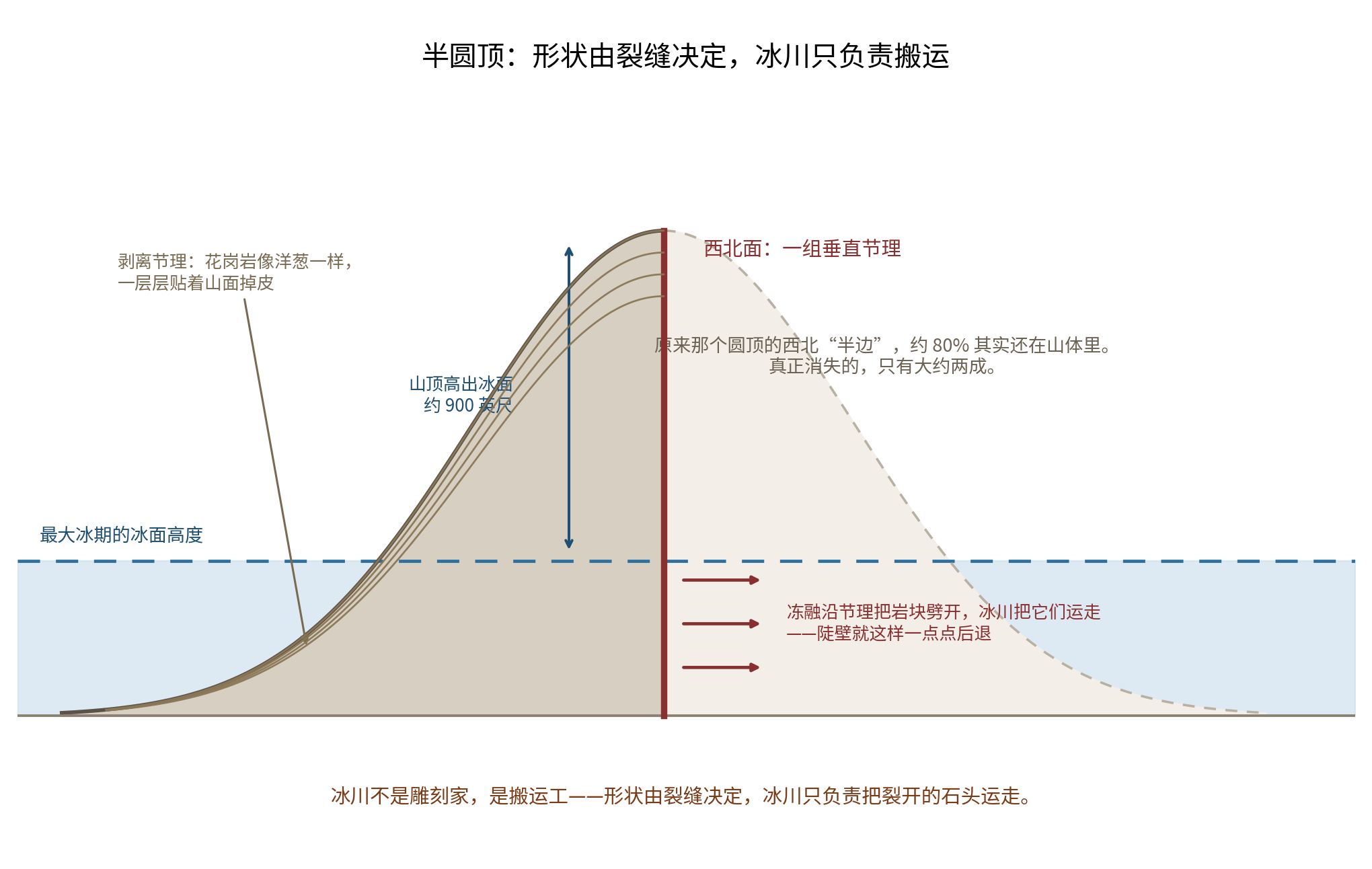
The familiar story says that Half Dome began as a complete dome and a glacier pushed past it, slicing away the other half.
The story is memorable and vivid. It has only one flaw: it is wrong.
US Geological Survey Bulletin 1595, geologist N. King Huber's The Geologic Story of Yosemite National Park, includes a sentence that seems written specifically for this misconception:
Half Dome is nearly as complete as it ever was. Seen from the valley floor, it appears to be a dome missing its northwest half, but that is an illusion.
Huber follows with an arrestingly precise figure: about 80 percent of the supposed northwest half is still there.
Only about one fifth is actually missing. The apparent "cut face" is not the scar of a blade. It is the mountain's own geometry.
How the Sheer Face Formed
If it was not sliced away, how did it acquire that shape?
The USGS divides the answer into three steps worth remembering intact.
First, the mountain rose out of the ground. Half Dome is made of granodiorite, magma that cooled deep underground in the Late Cretaceous, roughly 88 million years ago. Early USGS material gave an age of about 87 million years; modern high-precision uranium-lead dating of zircon gives 88.6 to 89.1 million years. The granite of nearby El Capitan is older, about 108 million years. Rocks in the same valley can differ in age by 20 million years. Later, overlying rock was stripped away layer by layer. As pressure eased, a weathering process called exfoliation took over: the granite peeled like an onion. That is how the dome acquired its rounded form.
Second, vertical fractures determined which face became a cliff. Granite contains natural joints, sets of cracks aligned in consistent directions. Half Dome's northwest face happens to contain a major set of vertical joints, the weakest line through the mountain.
Third, the glacier arrived, but it did something different from what the story suggests. It did not slice. It pried blocks loose along those vertical cracks and carried them away. Huber wrote that behind the small glacier above Mirror Lake at Half Dome's base, repeated freezing and thawing split the rock and made the cliff retreat bit by bit.
The distinction is essential: the glacier was not a sculptor but a porter. The cracks determined the shape; the glacier removed what had already broken.
The glacier never reached the summit. At the maximum extent of one glaciation, an official National Park Service handbook says Half Dome stood about 900 feet above the ice. Many peaks to its north were submerged completely; this one was not. It was a nunatak, its lower body buried in the ice field and its upper body in the sunlight.
The National Park Service offers a child-friendly summary: mountains completely buried in ice are rounded; mountains projecting above the ice are sharpened. Half Dome experienced both.
The Textbook Page Still Being Rewritten
The standard textbook explanation invokes unloading: pressure is removed and the rock rebounds. But that is not enough.
In 2006, geologist Stephen Martel pointed out that slabs can fracture parallel to a mountain's surface only when compressive stress also acts parallel to that surface. Such cracks open most readily where the landform is convex. That explains something important: exfoliation joints select domes rather than making every exposed rock peel.
In 2018, a team of USGS and National Park Service researchers added another factor: sunlight. Their paper in Nature Communications set several competing hypotheses beside one another and showed that thermal stress, the daily cycle of heating and cooling, can drive subcritical crack growth until a slab detaches with apparently no warning. Their example came from a granite dome at Twain Harte, California, in August 2014: a slab weighing about 8,000 kilograms launched itself into the air.
The question of why granite peels has been asked since the nineteenth century, and the answer is still changing. That does not mean the textbook was wrong. It means science kept going.
It Is Still Moving at Noon Today
If this sounds like a story from millions of years ago, the next experiment changes the scale.
In a 2016 paper in Nature Geoscience, Brian Collins and Greg Stock described monitoring a nearly vertical granodiorite exfoliation slab in Yosemite Valley. It was 19 meters high and 4 meters wide, but only 10 centimeters thick. They fitted it with sensors and measured it continuously for three and a half years.
The result:
The slab breathes every day. Heated by the midday Sun, its center bulged outward by an average of 8 millimeters, reaching as much as 13 millimeters, then contracted again at night. Across the year, the hottest months from June through September pushed it 21 millimeters farther out than the coldest months. At the lowest sensor, it moved outward by a net nearly 1 millimeter each year. Year by year, it is leaving the mountain.
The paper also gives a statistic. Among rockfalls with a thermal-stress trigger or no identified trigger, 15 percent occurred in the hottest period, July through September, and during the hottest hours, noon to 6 p.m.
The National Park Service has recorded more than 1,000 rockfalls in the park over the past 150 years. The USGS formal database catalogs 925 between 1857 and 2011. Forty-three were recorded in 2025.
Put those facts together:
Half Dome is not a finished mountain. Every noon it flexes outward by 8 millimeters, contracts at night, and works on itself more than three hundred times a year. The sheer face in the photograph is the result of that motion repeated hundreds of thousands of times. At noon today, it is still happening.
Google Calls Yosemite Famous for Waterfalls. Today the Falls Are Dry
This may be the most revealing fact in the whole story.
Yosemite Falls drops a total of 740 meters in three stages: the 1,430-foot Upper Fall, 675 feet of middle cascades and the 320-foot Lower Fall. The National Park Service calls it "one of the world's tallest waterfalls," not "the tallest in North America," a claim added elsewhere online.
The Park Service describes its season precisely: it runs approximately from November through July and peaks in May. By August, the park's falls are often reduced to a trickle or dry altogether.
The current-conditions page, updated August 19, one week before the Doodle appeared, said Yosemite Falls was basically dry. Bridalveil, Nevada and Vernal Falls were all running low after their spring flow.
Why? Because the waterfall is not a spring. It is last winter's snow.
When the mountain snowpack finishes melting, the waterfall switches off. For four or five months each year, it does not exist. Google says today that the park is famous for spectacular waterfalls, while its most famous waterfall is now a dark, dry stain on the cliff.
That absence may teach more than the torrent. A waterfall's water fell as snow months earlier and thousands of meters higher. Whether it appears depends on how much snow fell the winter before.
The National Park Service extends the line into the future. By 2100, annual snowpack in the Merced River basin could decline by 49 percent, snowmelt could arrive about a month earlier, and total runoff from April through July could fall by about 16 percent. In the agency's words, future visitors may find Yosemite's waterfalls at their fullest in winter, with bare cliffs and parched meadows by midsummer.
A Document Signed During the Civil War
Yosemite's legal history begins earlier than many people realize.
On Thursday, June 30, 1864, Abraham Lincoln signed the Yosemite Grant Act. The Civil War was still under way; Robert E. Lee would not surrender until the following April. A government fighting a civil war and short of money made time for a document transferring the valley and Mariposa Grove to California, to be held "for public use, resort, and recreation" and "inalienable for all time."
The National Park Service calls Yosemite the first natural scenic area in the United States set aside for public benefit and the beauty of its landscape. The qualifier is "in the United States," not "in the world." California returned it to federal control in 1906.
People lived here long before that document. The valley's Indigenous name is Ahwahnee, "place of the gaping mouth," and its people called themselves the Ahwahneechee, now part of the Southern Sierra Miwok. A National Park Service page records what happened on March 27, 1851, in restrained language: miners calling themselves the Mariposa Battalion tried to drive the Ahwahneechee from Yosemite, and their way of life was permanently disrupted.
The same page offers one concrete figure: a typical Ahwahneechee family consumed about 500 pounds of acorns a year. They called Yosemite Falls Cholok. In the reconstructed Indian Village of Ahwahnee on the valley floor, bark houses, a ceremonial roundhouse, a sweat house, acorn-pounding mortars and granaries remain. Local American Indian communities still hold ceremonies and gatherings there today.
For 120 Years, People Thought the Best Way to Protect Sequoias Was to Stop Fire
One final story about trees reverses an entire idea of protection.
Giant sequoias grow in Yosemite's Mariposa Grove. A National Park Service fire-ecology page makes the key point: the trees need fire. Fire helps open their closed cones, burns through the thick litter so seeds can reach soil, and opens the canopy to sunlight.
For roughly 120 years, from 1850 to 1970, managers did the opposite: they suppressed fire. Seedlings stopped establishing.
Beginning in 1970, rangers began deliberately setting fires.
In July 2022, the Washburn Fire entered Mariposa Grove. The US Fish and Wildlife Service later said that 50 years of prescribed fire and forest thinning reduced the fire's spread and intensity. The result was striking: not one giant sequoia was lost. Over those five decades, the park had burned more than 1,821 hectares in and around the grove.
Sometimes the right way to protect something is precisely the act instinct tells us to fear.
China Has a Granite Mountain and a Century-Old Argument
Half Dome's grammar of vertical joints making cliffs and exfoliation rounding domes appears across an entire Chinese mountain range.
That range is Huangshan.
A popular-science article from the Chinese Academy of Sciences system, published in both China Science Daily and the overseas edition of People's Daily and written by geologist Pu Qingyu, explains Huangshan this way. About 120 million years ago, underground magma cooled and solidified seven or eight kilometers below the surface. The rock then endured layer after layer of weathering and erosion, like peeling an onion. Around 13 million years ago, the Huangshan body gradually emerged at the surface. The principal reason for its sheer walls and sharp peaks is its well-developed granite vertical jointing: the cliffs of its peaks and the walls of its deep valleys are often exposed vertical joint surfaces.
Notice the shared language. American geologists say exfoliation peels granite like an onion. Chinese geologists say the same rock is "peeled like an onion." Two groups looking at their own granite reached for the same kitchen metaphor. Their explanations of vertical joints creating cliffs are virtually the same sentence.
One difference separates Huangshan from Yosemite.
Yosemite's glacial history can be reconstructed in detail from U-shaped valleys, terminal moraines and glacial striations. Researchers can even date moraines using cosmogenic beryllium-10. Whether Huangshan ever had glaciers, however, has remained unresolved in Chinese geology since Li Siguang proposed mountain glaciation there in 1922.
This is not mere stubbornness. The evidence differs in quality. In the low and middle mountains of eastern China, many supposedly glacial features can also be explained by debris flows, weathering or collapse. Science needs more than an explanation that works. It needs one that no competing process can supply.
Intriguingly, UNESCO's official Huangshan text says the landscape displays "good evidence of glaciation." That claim is exactly what the century-old argument concerns. Different institutions use different language for the same evidence, and that, too, is something worth showing a child.
Sources: US Geological Survey Bulletin 1595 (Huber, 1987); the USGS explanation of Half Dome's formation; National Park Service pages on Yosemite's geology, waterfalls, Horsetail Fall, rockfalls, fire ecology, snowpack and climate, the 1864 grant, and Indigenous history; the National Archives page on the Yosemite Grant Act; Martel (2006), Geophysical Research Letters; Collins et al. (2018), Nature Communications; Collins & Stock (2016), Nature Geoscience; zircon dating by Watts et al. in Geochemistry, Geophysics, Geosystems; the US Fish and Wildlife Service page on the Washburn Fire; the National Park Service announcement for National Park Week 2026; the official doodles.google page; Pu Qingyu, "A Scientific Puzzle: The Origins of Huangshan," published in China Science Daily and People's Daily Overseas Edition; UNESCO World Heritage Centre entries for Huangshan and Mount Sanqingshan; Yosemite Conservancy webcams; and USGS streamgage 11264500.