
A rocky coast, a 466-meter mountain, and the geometry behind a simple rule: the higher you stand, the sooner you see the Sun. Today is the first day of National Park Week in the United States.
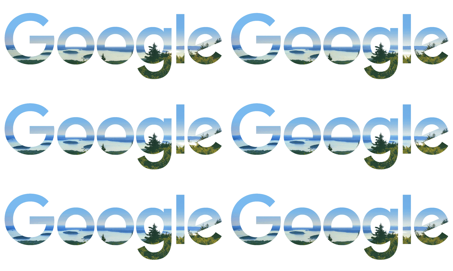
Image: Google Doodle, Celebrating National Parks Week: Acadia · Official page
Open Google today and the six colored letters above the search box have been replaced by the sea. Not a beach, but a rocky shore: granite worn by water and once pressed beneath glacial ice.
The Doodle is called Celebrating National Parks Week: Acadia. It depicts Acadia National Park in Maine and marks the opening of National Park Week. Google also released a Doodle for the start of the Serie A season today, but this story reaches much farther back than a soccer match - about 21,000 years.
The Picture
Google's official page says only that the Doodle celebrates National Park Week with the stunning views along Acadia's picturesque rocky coastline, in one of the few national parks on the East Coast. The page classifies it as a natural landmark and names no guest artist, so this time the coast itself must tell the story behind the picture.
Higher Ground Means an Earlier Sunrise
Acadia contains Cadillac Mountain. According to the National Park Service, it rises 1,530 feet, or 466 meters. That is modest as mountains go. Yet the NPS page for Cadillac Mountain makes a striking claim: from October 7 through March 6, it is the first place in the United States to see the sunrise.
Before memorizing that claim, consider a stranger question: why does climbing make the Sun arrive sooner?
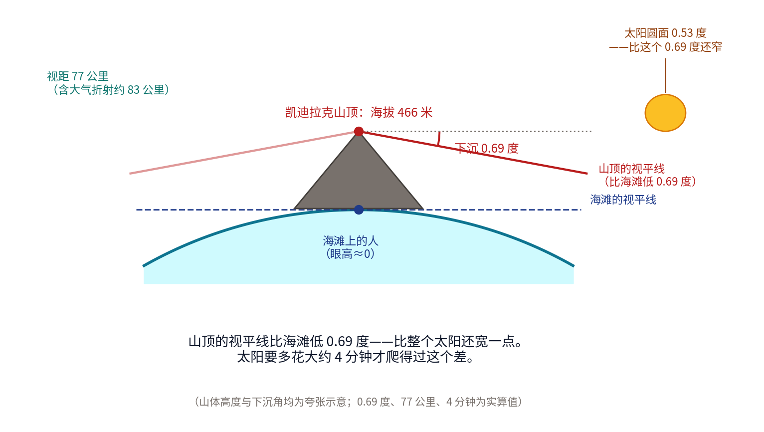
From a beach, the line where sea meets sky looks fixed. It is not. That line is where the curved surface of Earth drops from your view, and its position depends entirely on the height of your eyes. At beach level, the horizon is roughly 5 kilometers away and nearly level with your gaze. Climb to 466 meters and Earth's curvature opens a much larger view: the horizon retreats to about 77 kilometers away, or roughly 83 kilometers after allowing for atmospheric refraction. More important, it sinks by a full 0.69 degrees.
That sounds negligible. But the Sun's disk is only 0.53 degrees wide. In other words, the dip of the horizon from Cadillac Mountain is wider than the entire Sun. While someone on the beach still waits for its first edge to appear, someone on the summit can already see the full disk above the sea.
How much time does that buy? The Sun moves across the sky at 15 degrees per hour. At Acadia's latitude, where it rises at an angle, 0.69 degrees works out to about four minutes: 4.1 minutes on this date and a little more, about 4.6 minutes, at the winter solstice. Climb 466 meters, gain four minutes.
There is a graceful rule underneath the calculation: the horizon's angle of dip is proportional to the square root of height. Quadrupling your height only doubles the head start. From a 10-meter rooftop, sunrise comes just 35 seconds earlier than at ground level; from 100 meters, less than two minutes earlier. It takes the full 466 meters to reach four minutes. The place that catches "the first light" is never determined by coastline alone. Latitude, longitude, and elevation all compete for it.
That is also why Cadillac Mountain's "first in the nation" claim applies only from October 7 to March 6. The NPS gives those dates explicitly. Sunrise shifts north and south along the horizon during the year, toward the northeast in summer and the southeast in winter, so the first place to receive sunlight changes with the seasons. Other sites in Maine, farther east or north, take the distinction at other times. Any travel guide calling Cadillac Mountain the first place in America to see sunrise all year has omitted half the NPS statement. Today is August 22, outside the window.
One final detail is quietly moving. The Indigenous peoples of this coast call themselves Wabanaki, which Acadia's official NPS page translates as "People of the Dawnland." The same page says they may have lived here for as long as 10,000 years. Long before the first ray of sunlight was calculated in minutes and seconds, people had already made dawn part of their name.
Written by Ice
The shape of this rocky coast was carved not by the sea, but by ice.
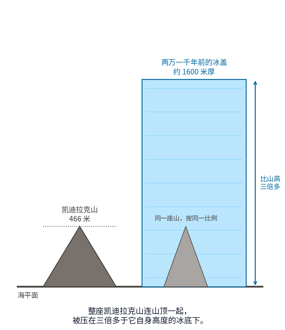
According to the NPS Geodiversity Atlas for Acadia, the continental ice sheet reached its maximum extent about 21,000 years ago, when the ice around Acadia may have been 1.6 kilometers thick. Put that beside Cadillac Mountain's 466 meters: the whole mountain, summit and all, lay under ice more than three times its own height. The rock from which visitors now watch sunrise once had well over a kilometer of ice above it.
The glacier's work remains spread across the landscape. The NPS geology page says ice eroded the mountains and cut broad U-shaped valleys. Ice moves forward as one mass, so unlike a river cutting a narrow channel downward, it grinds away the corners of an entire valley.
One of those U-shaped valleys later filled with seawater and became Somes Sound. Travel literature often calls it the only fjord on the East Coast. The NPS does not. Its first Earthcache page explicitly classifies Somes Sound as a fjard, not a fjord. A fjord is a long, narrow, seawater-filled glacial valley, hundreds of meters deep and bounded by steep cliffs; a fjard is a smaller drowned glacial bay. The page offers a comparison: Somes Sound measures 300 meters from seabed to mountaintop, while Norwegian fjords can exceed 1,000 meters. Strictly speaking, the "only fjord" line is an exaggeration.
The ice also played a grander practical joke. Acadia's famous Bubble Rock is a 100-ton boulder, about the size of a van according to the NPS, perched precariously on the edge of South Bubble Mountain. It looks ready to tumble. The odd part is that it is not local stone. The NPS Earthcache page identifies it as Lucerne granite and explains that this granite formed not on Mount Desert Island but near the town of Lucerne, about 30 miles northwest of Acadia. That is 48 kilometers. Ice carried a 100-ton boulder for 48 kilometers, rounding its edges along the way, and dropped it when the glacier melted.
The granite itself puts the glacier's work in perspective. The NPS dates Mount Desert Island's granite to about 420 million years ago. Against it, the ice age 21,000 years ago was only the latest mishap.
A Fire Rewrote the Colors of Fall
Acadia bears a newer scar, and today that scar has become color.
According to the NPS page Fire of 1947, the blaze began at 4 p.m. on Friday, October 17, 1947. It was not declared fully extinguished until 4 p.m. on November 14, nearly a month later. It burned 17,188 acres, about 70 square kilometers, including more than 10,000 acres inside Acadia National Park. On Bar Harbor's "Millionaires' Row," 67 summer estates burned to the ground; another 170 homes and five historic hotels were destroyed in town. The Army Air Forces, Navy, Coast Guard, forestry students from the University of Maine, and people from Bangor Theological Seminary all fought the fire. Four people died, including an elderly man who went back to rescue his cat.
The forest that returned was not the one that burned. The NPS says the previously dominant spruce and fir gave way to sun-loving species such as birch and aspen. It was a complete change of guard: spruce and fir seeds germinate in shade, but once the fire opened the canopy, sunlight flooded the ground and birch and aspen quickly filled it.
That history remains visible. In autumn, Acadia is divided in two. Areas spared by the fire remain evergreen, keeping one color through the year. Burned slopes turn red, yellow, and orange each October. In the NPS description, what had been a monotonous evergreen forest became a brilliant mix of color from a diverse deciduous forest. The boundary traced by the fire 79 years ago is now a boundary of autumn color, a map that redraws itself every year.
A Park Given Away
The order of this story matters: the Wabanaki were here first. The NPS page on the Wabanaki at Acadia says they may have lived here for 10,000 years, and that some called Mount Desert Island Pemetic, meaning "range of mountains." Today's Wabanaki comprise five tribal governments: the Houlton Band of Maliseet Indians, Mi'kmaq Nation, the two Passamaquoddy communities at Motahkokmikuk and Sipayik, and the Penobscot Indian Nation. The page opens with a sentence that cannot be misread: "Wabanaki people are still here." It belongs before the story of donated land; otherwise that story erases people already living on it.
Now to the donations. Acadia is unusual among American national parks. It was not carved from federal land, but assembled parcel by parcel by private citizens.
According to the NPS history of Acadia, George B. Dorr and several associates founded the Hancock County Trustees of Public Reservations in 1901. Another leader was former Harvard president Charles W. Eliot. By 1913, the trust had accumulated 6,000 acres. In 1916, Dorr gave 5,000 acres to the federal government, allowing President Woodrow Wilson to establish Sieur de Monts National Monument. Wilson signed legislation making it Lafayette National Park in 1919. In 1929, Congress authorized the NPS to accept a donation on the Schoodic Peninsula, and the park was renamed Acadia that year. An interpretive sign in the park says the group succeeded in establishing the first national park east of the Mississippi River, and one of the very few composed almost entirely of land donated to the federal government.
Another donor gave roads rather than land. John D. Rockefeller Jr., heir to the oil fortune, built a network of motor-free carriage roads on the island from 1913 to 1940. The NPS history gives the figures: 45 miles, about 72 kilometers, of carriage roads, and funding from Rockefeller for 16 of the 17 stone-faced bridges. The roads are about 16 feet, or 4.9 meters, wide and use the early-20th-century broken-stone method: three layers of stone with a crown of 6 to 8 inches for drainage. Rockefeller personally walked the staked routes to supervise construction. A century later, the roads remain and cars are still excluded.
Today Acadia protects more than 47,000 acres, about 190 square kilometers, according to the park's official fact sheet. The NPS owns 35,332 acres, while another 12,416 acres are protected by conservation easements on private land. This small park, smaller than many urban districts in China, receives more than four million recreational visits each year.
Why Today
Today, Saturday, August 22, 2026, is the first day of National Park Week in the United States.
According to the official NPS page, National Park Week runs for nine days, August 22 through 30, with a theme for each day. The week's center of gravity falls on Tuesday, August 25: the 110th anniversary of the National Park Service, founded on August 25, 1916, and a fee-free day.
Anyone familiar with the event may notice that the timing looks wrong. National Park Week has traditionally been held in April. This year it moved. A March 20, 2026, release from the NPS communications office says the week would be held from August 22 to 30 to celebrate the National Park Service's 110th birthday and the 250th anniversary of American independence. The release connects the new dates to those anniversaries but does not explain why the event moved from April. Where the record stops, so should we: this year, the official week was shifted to the NPS birthday.
China: Another Way to Assemble a Park
Acadia's story is about people giving away their own land. China's national parks were assembled by a different route.
On October 12, 2021, China formally established its first five national parks: Sanjiangyuan, Giant Panda, Northeast China Tiger and Leopard, Hainan Tropical Rainforest, and Wuyishan. According to China's National Forestry and Grassland Administration, together they protect 230,000 square kilometers and nearly 30 percent of the country's key nationally protected terrestrial wildlife and plant species. Acadia covers 190 square kilometers; the five Chinese parks together are about 1,200 times larger.
Their method of formation was nearly the reverse of Acadia's. A 2025 departmental update on the Chinese government website described a process of scientifically merging nature reserves, adjusting their boundaries and zones, and addressing unclear borders, overlapping designations, protection gaps, and conflicts between conservation and development. In ordinary language, the land was already protected, but split into pieces under different authorities: some areas had overlapping protection, while others had none. The national-park system joins those fragments and places them under unified management. One model assembles private land into a public whole; the other consolidates scattered public authority. Both answer the same question: who is responsible for this place?
China's National Park Law took effect on January 1, 2026. According to the National Forestry and Grassland Administration, its seven chapters and 63 articles were adopted by the 17th session of the Standing Committee of the 14th National People's Congress on September 12, 2025. One provision reads especially well beside Acadia: the law encourages and supports public participation in national-park conservation and varied forms of nature and environmental education, and specifies that ecological steward positions created for conservation needs should give priority to local residents.
This is more than language on paper. The same agency says the first five parks have hired more than 50,000 community residents as ecological stewards, with annual wage income of RMB 10,000 to 20,000 per person. Sanjiangyuan's "one household, one post" program employs 23,000 local residents in patrol and management work. The Northeast China Tiger and Leopard National Park selected 8,139 people for its version of the program, raising household income by about RMB 10,000 on average. A century ago, wealthy landowners gave their vacation estates to create Acadia; at Sanjiangyuan, people who live on the land have become its custodians.
The National Forestry and Grassland Administration also says Wuyishan National Park has developed ecological fieldwork, school outreach, and nature education through its science-education bases, along with recreational routes open to the public. Beyond the five existing parks, the National Park Spatial Layout Plan identifies 49 candidate areas totaling about 1.1 million square kilometers. Preparatory work is under way at 18 sites, including the Yellow River Estuary, Qianjiangyuan-Baishanzu, and Shangri-La, under the principle of establishing each park when it is ready. In the coming years, a place nearby may become a national park. It may still be called a nature reserve or forest park today, but the landscape underneath the name is already there.
Sources: Google Doodles, Celebrating National Parks Week: Acadia (doodles.google); National Park Service (National Park Week page, fee-free-days page, March 20, 2026 National Park Week release, Cadillac Mountain page, vehicle-reservation page, fees page, park fact sheet, geology page and Geodiversity Atlas, Earthcache stops for Somes Sound and Bubble Rock, Fire of 1947, Wabanaki Nations, A History of Acadia, Founding Acadia, historic carriage roads, Creating Acadia interpretive sign, and Secrets of the Summit); China's National Forestry and Grassland Administration; the Chinese government website; and China News Service.