
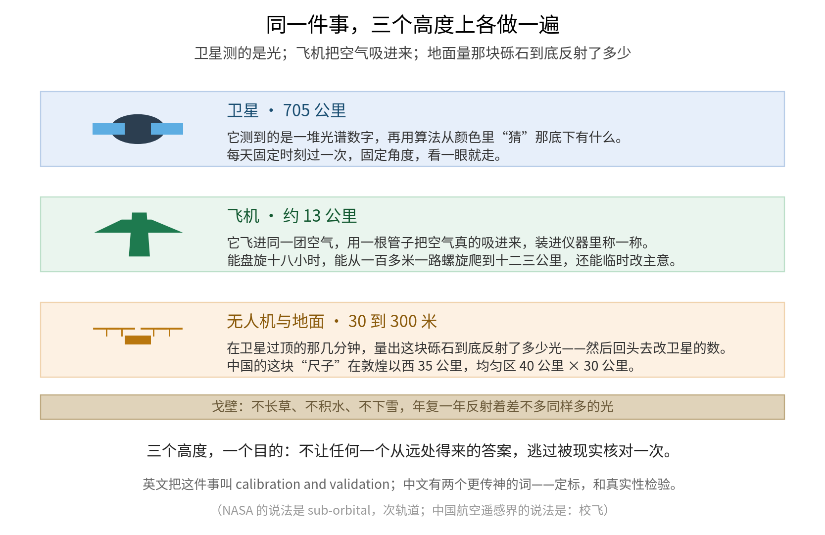
A satellite guesses from color 700 kilometers away. An aircraft enters the same air and draws it into an instrument. Only together do they produce a trustworthy answer.
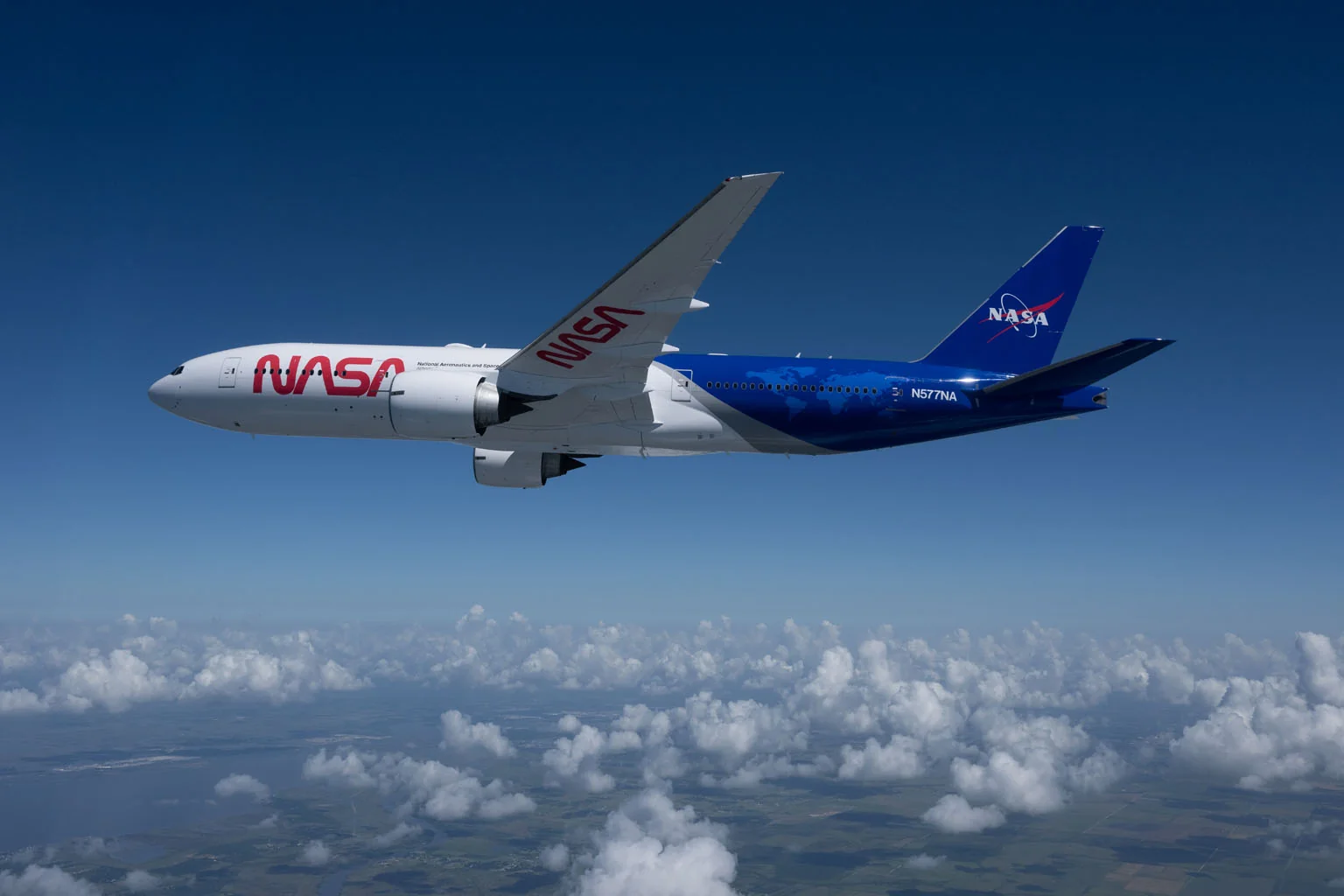
Image: NASA Image of the Day · Image credit: NASA/James Blair · Image page
Yesterday's NASA Image of the Day was a freshly painted Boeing 777.
The photograph was taken on August 11, 2026. NASA's own text is barely more than a sentence: "NASA's Boeing 777 shows off its new paint scheme." The caption adds that it was returning to Langley Research Center after being painted.
Does a new coat of paint on an airliner merit NASA's picture of the day?
It does, because this aircraft is taking over from NASA's DC-8, the flying laboratory retired in 2024. Its new job contains a question most people have never considered.
If We Have Satellites, Why Fly Into the Atmosphere?
Hundreds of Earth-observing satellites already watch the planet. They do not sleep or eat, and they see both farther and more broadly than an aircraft. So why send up a plane?
The first part of NASA's answer appears in the image description. The 777 will support sensor development, calibration of satellite sensors, validation of data products, and field studies intended to improve our understanding of Earth-system processes.
The second part lies in those words "calibration" and "validation." NASA's Landsat guidance provides standard definitions. Calibration determines and applies corrections to sensor parameters so that the output numbers truly correspond to physical quantities. Validation independently assesses whether higher-level products, such as surface reflectance or land-cover classifications, are true.
The third part is the key. The first of the NASA Airborne Science Program's four goals is to provide platforms for essential calibration measurements of Earth-observing satellites and for validating data-retrieval algorithms.
Those last words matter: retrieval algorithms.
The Sentence That Explains It
A satellite never measures the air itself. It measures light returned by the air.
From 700 kilometers away, a satellite receives a field of spectral data: one band slightly brighter, another slightly darker. It does not directly know how much nitrogen dioxide or smoke lies below, or how high the cloud base is. An algorithm infers those things from color.
An aircraft can enter the same parcel of air, draw it through a tube into an instrument, and measure and count what is actually there.
The aircraft flies into the same air and samples it directly, then tells the satellite whether its inference was right.
NASA has an apt term for the aircraft: a suborbital platform, the layer above the ground but below space. Another of its missions is stated plainly: new instruments and algorithms can fly there for several years to reduce risk before a sensor is delivered for launch.
An instrument proves itself here before it earns a place on a rocket.
Satellites Can Never Buy Freedom
Beyond the difference between measuring light and collecting samples, aircraft have another advantage: satellites have no freedom.
Consider two of NASA's best-known Earth-observing satellites. Terra passes overhead once each day, always at about 10:30 a.m. Aqua does the same at about 1:30 p.m. Orbiting 705 kilometers above Earth with a 2,330-kilometer swath, they cover the globe every one to two days.
A satellite always looks at that time and from that angle, then moves on.
NASA's official figures for the 777 tell a different story: 18 hours of endurance, a ceiling of 43,000 feet, or about 13.1 kilometers, a range of 9,000 nautical miles, or about 16,700 kilometers, a payload of 75,000 pounds, or about 34 metric tons, and room for 50 to 100 operators.
It can circle the same patch of sky for 18 hours. It can change its mind at short notice, following a storm or steering around it.
Most important, it can move repeatedly through the vertical dimension. A 2021 National Academies report on airborne platforms describes the DC-8's capability in concrete terms: it routinely flew vertical profiles, spiraling from 150 meters above the sea to its cruising altitude of 12.5 kilometers.
A satellite can only retrieve a vertical profile. The aircraft actually travels through it.
The report also explains why the platform must be large. Complex instrument arrays need enormous amounts of power: the DC-8 mission average was 25 kilowatts, along with strong mounting structures. A small aircraft cannot carry the load.
The Aircraft It Replaces Deserves Its Own Story
NASA's DC-8 was a DC-8-72, tail number N817NA. Built in 1969, it first flew for Alitalia. NASA bought it in 1985 for $24 million including modifications, began science operations in 1987, and based it for decades at Armstrong Flight Research Center in Palmdale, California.
Its instrument payload was 13.6 metric tons, and total payload including people and cargo was 22.7 metric tons. It could seat 42 experimenters plus eight crew members. Historical missions used an average of 21 science seats, while major deployments carried more than 30 researchers.
This was not an airplane carrying a few instruments. It was a flying laboratory hall.
Beginning in 1987, it logged 11,745 mission hours across more than 140 airborne science campaigns. Its first assignment was an airborne investigation of the Antarctic ozone hole. Later came the Global Tropospheric Experiment; Operation IceBridge, when laser altimeters, radar, cameras and gravimeters measured "the ice the satellites would have flown over" during the data gap between the end of ICESat and the launch of ICESat-2; and a 2019 study of wildfire smoke plumes.
Its final major campaign has particular resonance in East Asia. From January to March 2024, ASIA-AQ, a joint field study of Asian air quality, deployed to the Philippines, Taiwan, South Korea and Thailand. One of its central tasks was to validate South Korea's GEMS, the world's first air-quality spectrometer in geostationary orbit, which takes a measurement every hour.
An orbiting instrument that produces an hourly picture of East Asia still needs someone to fly into the air below and check it.
On Wednesday, May 15, 2024, the DC-8 made its final flight to Idaho State University. It now serves as a teaching aircraft for the university's Aircraft Maintenance Technology program. Idaho State says the aircraft that measured the atmosphere for 37 years quickly became a cornerstone of the program.
Its Most Beautiful Mission: Sewing Through the Atmosphere
If only one DC-8 mission could be told, it would be ATom, the Atmospheric Tomography Mission.
The premise was almost blunt: if satellites can only look down from above, then researchers would measure the entire atmosphere in person.
There were four deployments, one in each season: July-August 2016, January-February 2017, September-October 2017, and April-May 2018. Each lasted about 26 to 28 days. The route began in California, ran north to the Arctic, then south across the Pacific into high southern latitudes. It turned east into the Atlantic, climbed north toward Greenland, crossed the center of North America and returned to California.
The DC-8 did not fly level along that route. It repeatedly plunged and climbed, from 100 or 200 meters above the sea to 12 or 13 kilometers, then down and up again.
The mission's overview paper gives the figures:
- 48 research flights
- 645 vertical profiles
- 301,000 kilometers flown, equivalent to 7.5 trips around Earth's equator
- More than 400 flight hours
- An altitude range of 0.15 to 13 kilometers
- 22 instruments at first, with five added later
- About 60% of the time spent profiling vertically and 40% in level flight
On average, each flight climbed and descended through the atmosphere 13 times. A passenger aircraft built in 1969 carried more than 20 instruments and roughly 40 science seats around the planet in four seasons. The result was humanity's first three-dimensional map of global atmospheric chemistry.
Some of its findings landed hard.
There is no clean air anywhere on Earth. Aged biomass-burning plumes are widespread. At every altitude, they account on average for more than 27% of accumulation-mode aerosol number concentration, even above oceans far from any continent.
The atmosphere does not clean itself evenly. It removes pollutants with hydroxyl radicals, OH, often called the atmosphere's "detergent." Measurements found a startling distribution: OH concentrations over the tropical western Pacific were ten times lower than in the surrounding region. In some places, the air cleans itself slowly.
Another result forced models to be rewritten. Earlier models had greatly overestimated aerosols in the upper troposphere. ATom data reduced simulated abundance by several orders of magnitude.
One aircraft made four circuits and changed a model result by orders of magnitude. That is the weight carried by the word "validation." Without it, no one knows how wrong the model may be.
NASA's Fleet Is Really a Ladder of Altitudes
Once this logic is clear, NASA's research fleet makes sense as a ladder whose rungs stop at different heights.
- The ER-2, a civilian derivative of the U-2 reconnaissance aircraft, has a ceiling of 70,000 feet, or 21.3 kilometers, in the lower stratosphere. Its perspective there closely resembles a satellite's, so it often "simulates a satellite" for calibration and validation.
- The unmanned Global Hawk reaches 65,000 feet and can remain aloft for 30 hours.
- The WB-57 reaches more than 63,000 feet depending on payload and carries 8,800 pounds: high-altitude heavy lift.
- The Gulfstream V reaches 51,000 feet and flies for 13 hours.
- The Boeing 777 reaches 43,000 feet, flies for 18 hours and carries 34 metric tons: a globally deployable giant laboratory.
- The P-3 Orion reaches 32,000 feet, flies for 12 hours and carries 18,000 pounds: low, slow and all-weather.
Add the DC-8's former sampling runs just 150 meters above the sea, and the ladder extends continuously from near the surface to the lower stratosphere.
Every altitude has its own question to answer.
The 777 Itself
NASA identifies the aircraft as a Boeing 777-200ER, built in 2003, with tail number N577NA. Based at Langley Research Center, it was purchased in 2022 and is due to enter service in fiscal year 2027. Aviation media report that it previously flew for Japan Airlines.
L3Harris carried out the conversion in Waco, Texas, and delivered it to Langley on April 22, 2026, five weeks ahead of schedule. The work resembled the construction of a laboratory: dedicated research stations and extensive wiring were installed, the cabin windows were enlarged, and downward-looking ports were opened in the belly. The project required nearly 35,000 precision-drilled holes in the airframe.
NASA's project manager says the 777 will be the largest airborne research laboratory in the fleet. Another manager called the DC-8 an "incredible workhorse" for Earth science for nearly 40 years, while describing the 777's ability to bring together more partners and more educational opportunities.
Its first science mission is called NURTURE, a study of high-impact winter weather: severe cold-air outbreaks, high winds, blizzards and ice storms, and extreme precipitation. Phase one will use a Gulfstream III in winter 2026; the 777 joins for phase two in 2027.
NASA and the contractor describe dedicated research stations and several nadir and window ports, but neither has published a number for either. No number can responsibly be supplied.
Why the New Paint?
The honest answer is that there is no mysterious technical reason. NASA has never offered an aerodynamic or optical explanation for the white-and-blue scheme.
NASA routinely repaints aircraft and renews their markings during scheduled maintenance. The markings themselves do have a history:
- The round blue insignia known as the "meatball" was designed in 1959 by NASA employee James Modarelli, a year after the agency was founded.
- The joined NASA wordmark known as the "worm" was introduced in 1975, designed by the firm Danne & Blackburn, and retired in 1992.
- It returned in 2020, first appearing again on the Falcon 9 rocket for a crewed test flight. NASA's announcement consisted of one line: "The worm is back."
A fresh coat of paint on a research aircraft is a sign that it is nearly ready to work.
China Does the Same Work With a Desert
The need to check satellites against reality is taken just as seriously in China, through some remarkably concrete methods.
Dunhuang: A 1,200-Square-Kilometer Ruler
About 35 kilometers west of Dunhuang in Gansu lies a stretch of Gobi used as a standard ruler: the Dunhuang National Radiometric Calibration Site.
Approved in 1997, it entered operational service in 2002, won a second prize in the State Science and Technology Progress Awards in 2012, and was named a national field scientific observation and research station in 2018. Its coordinates run from 40°00' to 40°20' north and 94°00' to 94°30' east. The uniform area measures 40 by 30 kilometers, or 1,200 square kilometers. Its surface is mostly gravel, sand and dust, sloping from north to south.
Why a desert? A calibration site must not change. It needs a surface large enough, uniform enough, dry enough and stable enough in reflectance. No vegetation grows there, and water and snow do not accumulate. Year after year, it reflects roughly the same amount of light.
During the few minutes when a satellite passes overhead, people on the ground are working too.
The 2024 synchronous satellite-ground experiment involved the National Satellite Meteorological Center, the Chinese Academy of Sciences' Anhui Institute of Optics and Fine Mechanics, and other participants. The satellites included Fengyun-3D, 3F and 3G, and Fengyun-4B. Ground equipment included solar absorption spectrometers, aerosol lidar and carbon-dioxide lidar, along with an angular observation platform that mimicked a satellite's viewing geometry at a fixed point.
The critical step was this: an automated drone observation system flew as the satellites passed overhead to measure surface reflectance.
Published research shows the level of detail involved. An eight-rotor drone carrying a spectrometer could fly for 48 minutes with a five-kilogram payload. It hovered to observe at 30, 50, 80, 100, 150, 200, 250 and 300 meters above a 10-by-10-kilometer sampling area. Researchers fed the measured surface reflectance into an atmospheric-transfer model, predicted how bright the site should look from orbit, and compared the prediction with the satellite's actual measurement. Except in two shortwave-infrared bands, mean relative differences were within 5%.
The structure is the same at every scale. A satellite measures light from 705 kilometers away. A drone 300 meters above the ground measures how much light the gravel actually reflects. Then that result is used to correct the satellite.
NASA uses a 777 for this work. China uses a Gobi desert and a fleet of drones. The purpose is the same.
Baotou: One of the World's Four Shared Rulers
Farther east, Baotou in Inner Mongolia has two calibration sites with an important status: together they are one of the four reference sites in the global RadCalNet network.
RadCalNet, operated under the Committee on Earth Observation Satellites, provides satellite operators with top-of-atmosphere spectral-reflectance products traceable to the International System of Units. The data are used for post-launch calibration and validation of optical sensors, covering wavelengths from 400 to 2,500 nanometers in 10-nanometer samples, produced every 30 minutes and continuously archived.
There are four sites worldwide: Railroad Valley Playa in the United States, La Crau in France, Gobabeb in Namibia, and Baotou in China, operated by the Chinese Academy of Sciences' Aerospace Information Research Institute in cooperation with the United Kingdom's National Physical Laboratory and China's National Institute of Metrology.
The Baotou targets are built like instruments. The artificial grayscale area consists of two white, one gray and one black uniform gravel squares, each measuring 48 by 48 meters. There is also a 300-by-300-meter natural sand site. These targets have been used for absolute on-orbit radiometric calibration of Chinese satellites including Gaofen-7, producing linear correlation coefficients better than 99% in every band and calibration uncertainty better than 5%.
Of the world's four shared rulers, one lies in Inner Mongolia.
China Has Research Aircraft Too
The Aerospace Information Research Institute operates a national major science and technology infrastructure known as the Airborne Remote Sensing System, which passed national acceptance and entered formal operation on July 22, 2021.
It includes two Chinese-built MA60 remote-sensing aircraft and two Cessna Citation S/II remote-sensing aircraft, equipped with more than ten types of remote-sensing payload, among them atmospheric-environment lidar, differential absorption spectrometers and multi-angle polarimetric radiometers.
The two Citations are veterans. The first-generation Citation remote-sensing aircraft made its maiden flight on June 28, 1986. With a maximum range of 3,300 kilometers and ceiling of 13,100 meters, it carried aerial cameras, imaging spectrometers, imaging radar and other sensors. It accumulated more than 10,000 safe sorties and surveyed more than two million square kilometers of China's territory. The MA60 is the second generation. It formally entered service in July 2021 and, in official wording, filled China's gap in large, multifunctional remote-sensing aircraft.
Their listed work explicitly includes calibration flights: calibration flights for aeronautical and spaceborne payloads, final testing of remote sensors, and calibration flights for new remote-sensing payloads.
NASA calls it suborbital calibration and validation. The aircraft in China do the same essential work.
Sources: NASA Image of the Day for August 18, 2026; official NASA Airborne Science Program pages on program goals and specifications for the B777, DC-8, ER-2, Global Hawk, WB-57, Gulfstream V and P-3; NASA Science guidance on Landsat calibration and validation; NASA Langley Research Center's report on the 777's return; the L3Harris delivery release; NASA reports on the DC-8's retirement, final flight and scientific record; the National Academies' Airborne Platforms to Advance NASA Earth System Science Priorities (2021); the ATom mission overview paper in the Bulletin of the American Meteorological Society (2022) and NASA ESPO mission archive; NASA's ASIA-AQ and Operation IceBridge mission pages; NASA's official history of its insignia; NASA's NURTURE mission page; LADS Web guidance on MODIS and the Terra and Aqua orbits; a China Meteorological Administration report on the Dunhuang National Radiometric Calibration Site's 2024 synchronous satellite-ground experiment; a Spectroscopy and Spectral Analysis paper on synchronized drone observations at Dunhuang; the official CEOS RadCalNet page and USGS page on the Baotou site; a Remote Sensing paper on the Baotou RadCalNet site; a National Remote Sensing Bulletin paper on absolute on-orbit radiometric calibration of Gaofen-7 at Baotou; official pages from the Chinese Academy of Sciences' Hefei Institutes of Physical Science and the national Airborne Remote Sensing System major research infrastructure; reports from the Chinese Academy of Sciences' Aerospace Information Research Institute on the Citation and MA60 remote-sensing aircraft; NASA Worldview; the official GLOBE Observer Clouds tool; and the National Satellite Meteorological Center's satellite imagery page.